Two Illinois professors have been named geospatial fellows for the Geospatial Software Institute (GSI) Conceptualization Project, which aims to study the spread and impact of COVID-19 and offer solutions to vulnerable populations it has affected.
Ruby Mendenhall and Andrew J. Greenlee comprise a list of 16 researchers from 13 universities with projects aimed at addressing issues related to access to healthcare and food systems, as well as racial and disability disparities during the COVID-19 pandemic.
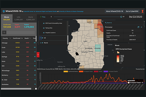
The GSI Conceptualization Project, supported by the National Science Foundation (NSF) and led by Illinois’ CyberGIS Center for Advanced Digital and Spatial Studies (CyberGIS Center), aims to develop a strategic plan for a long-term hub of excellence in geospatial software infrastructure that more effectively addresses pressing societal issues relating to food security, public health, and social resilience, among other concerns.
Mendenhall, professor of sociology and African American studies, will focus her fellowship work on helping underrepresented students in computer science evaluate and analyze the impact of COVID-19 on the vulnerable communities in which they reside.
Mendenhall’s Youth Citizen Community Scientists Mapping project will provide 50 to 100 students whose parents do not have college degrees and who are at risk of dropping out of school with computer science activities such as using spatial analysis to map vulnerable communities or hotspots. The project will also seek to have the outcomes of the students’ work published over various platforms including National Geographic magazine.
Greenlee, professor of urban and regional planning, focuses his research on the intersection of housing policy, poverty, and social equity within cities and regions. Using New York City as a pilot case, Greenlee’s fellowship project will focus on the development of a novel system for tracking pre-eviction and post-eviction residential locations and household characteristics.
Cyber geographic information science and systems (GIS) is a new generation of GIS, combining advanced cyberinfrastructure and GIS with spatial analysis and modeling capabilities. This seamless integration leads to widespread research advances and broad societal impacts. The geospatial fellows will be conducting their projects using a variety of geospatial software and advanced cyberGIS capabilities.
The NSF GSI Conceptualization Project is being carried out in partnership with the American Association of Geographers, Consortium of Universities for the Advancement of Hydrologic Science, Inc., the National Opinion Research Center at the University of Chicago, Open Geospatial Consortium, and University Consortium for Geographic Information Science. Technical leadership and cyberinfrastructure support are provided by the CyberGIS Center.
“The COVID-19 crisis has shown how critical it is to have cutting-edge geospatial software and cyberinfrastructure to tackle the pandemic’s many challenges,” said Shaowen Wang, Illinois professor and head of the Department of Geography and Geographic Information Science. Wang, who is also the principal investigator of the NSF Project and founding director of the CyberGIS Center, is excited to see the potential impacts of the fellows’ work.
“We are extremely grateful for NSF’s support to fund this talented group of scholars, whose work is so diverse yet complementary,” he said.