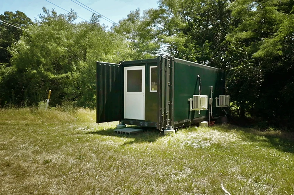
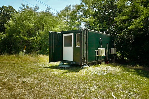
Located on the bank of the Sangamon River near Monticello, Illinois, sits the University of Illinois RiverLab, built to study the chemical makeup of the river—and provide insights into inland surface waters like never before.
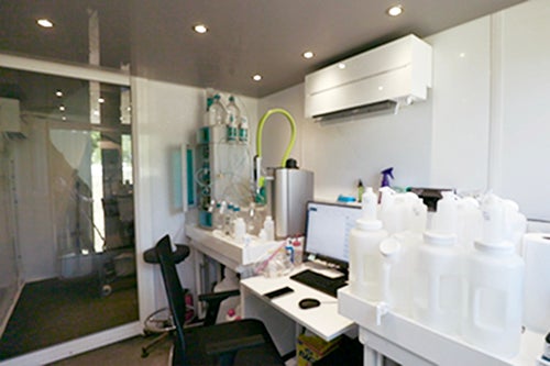
Situated near an array of scenic woodlands, grassy fields, and farms, the RiverLab is no bigger than a shipping container, but it’s far more sophisticated. The front half is a fully functional chemistry lab to analyze the solute concentrations of the river water, and the back half is a pump and filtration system that keeps the water flowing.
"The whole idea is, rather than sending people out here once in a while with sample bottles, we’re actually going to put the lab in the location that we want to make the measurements and semi-autonomously have it function around the clock in real time,” said Jennifer (Jenny) Druhan, professor of geology. “The whole plan is to move water out of the river, filter it again and again, and eventually supply a very small amount into a chromatography system where we can measure the full suite of major chemicals that are dissolved in the river.”
The RiverLab is located at the previous site of the Intentionally Managed Landscape Critical Zone Observatory (IMLCZO), part of a set of Critical Zone Observatories established by the National Science Foundation (NSF) about 10 years ago, which addressed questions about the relatively thin veneer of Earth's surface that extends from the top of the tree canopy to the base of weathered bedrock.
After the Critical Zone observatories ran their course, the RiverLab was established about a year ago as part of a new generation of the NSF-funded program which utilizes networks of researchers to continue the work of understanding what was happening on and within the surface of our landscape.
Several units at the U of I have a hand in operating the laboratory, including the Prairie Research Institute, Illinois State Water Survey, the Department of Civil and Environmental Engineering, and the Department of Geology.
“We are able to, in some ways, upgrade, expand and reimage the scope of what has been done for a long time. This river and this location were a big part of that original program, so it made a lot of sense for us to put the RiverLab here,” Druhan explained.
The RiverLab is also located about 20 meters away from one of the longest operating United States Geological Survey gauge stations, which provides a decades-long record of how much water has been moving through the river. The data from these gauge stations are used to understand floods and manage surface water resources.
“We’ve never had the chemical record to go with that water record before and that’s what (RiverLab) does,” Druhan said. “Finally, we’re starting to get the chemographs to match the hydrographs from these gauge stations.”
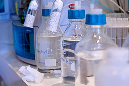
RiverLab researchers are measuring the major anions and cations, such as sulfate, nitrate, phosphate, and other nutrients that give clues to what’s happening to the landscape within the agricultural environment where the lab is located. They are also interested in silicon, calcium, magnesium, and sodium, which come from natural rock weathering and end up in the river.
“We’re using all that high resolution data to understand how these rivers function, how they export chemicals from the landscape, their water quality, what happens during storms, what happens across seasons, at this exquisite resolution of data that we haven’t had before,” Druhan explained.
Water is extracted from the river through the pump and sent through filtration systems and physical probes to record the pH, dissolved oxygen, turbidity, temperature and conductivity of the water.
The RiverLab is the only fully operational lab of its kind in North America. Up until now, researchers have largely been restricted to collecting river water in sample containers and bringing it back to campus to be studied. However, as Druhan explained, this causes researchers to miss out on many important points of data collection.
For example, it’s rare and possibly even dangerous to send someone out to sample during a big storm, so they’re missing out on a huge export of nutrients in the river. Druhan explains that during big storms when the river is rising rapidly, “there is a lot of water getting put through this system and you would imagine that it would mean that these chemical concentrations, these elements, would get diluted. Yet, in this river, we see that the chemistry and concentration keeps up with the flow. Somehow more water means more solutes, which is really interesting.”
She added: “We’ve seen this in other rivers before, but not at this resolution. If you put lots of water into the river, like a huge storm, you do eventually start to dilute those solutes, but not all of them. Some of them, like potassium and other nutrients actually get more concentrated when you’re putting more flow through the river.”
Several researchers rely on the RiverLab for data. Druhan is working with Praveen Kumar, professor of civil and environmental engineering. Bruce Rhodes, a professor of geography and geographic information science, is using RiverLab to study extended sediment in the water, which can affect dams over time. The lab has helped researchers understand how the chemistry of soil impacts the amount that runs off into the river, and, with the help of eddy covariance flux towers, other researchers have examined levels of carbon dioxide and water vapor to better understand the exchange between river ecosystems and the atmosphere.
“You can start to see how, all together, this is a project that is really trying to quantitatively explain this landscape. It’s fun to be in this collaborative environment as part of this new facility,” Druhan said. “What’s so fun about this opportunity is that it spans the entire spectrum. If you’re interested in infrastructure, chemistry, machine learning, there’s an opportunity for you here. There is so much available to work on.”
This includes many opportunities for student involvement, Druhan said. Many components of the RiverLab need students to help maintain them to keep the lab functional, such as physical probe calibration so they can be developed for their own data streams, and keeping pumps running, lines clean, and filtration systems.
After one year of operating the RiverLab, researchers have learned a lot, especially about maintaining the lab. Druhan would like to increase the lab’s functionality through the winter because it would provide insights during a time when few scientists actually study rivers.
“Nobody puts a [sample] bottle in the river when the river is frozen over,” Druhan explained. “Nobody has been able to see the chemistry and what happens in these systems as the water is moving under the ice, especially at this resolution.”
Despite difficulties, the lab did produce physical data this past winter, such as dissolved oxygen levels, which Druhan says she is excited to expand this winter. In the long-term, Druhan hopes to build out a larger network of RiverLabs across the country. Currently, there are three RiverLabs deployed in France, one that is coming online in China, and two set to come online in Canada.
“I strongly believe that it is worth it (to build similar labs), and having a network of them would really catalyze the data that we’re generating from this one location,” said Druhan.
The RiverLab is exploratory, she said, and it provides researchers with data they’ve never gotten before, especially on a river of this size at such a high frequency.
“It’s my version of sending up a satellite,” Druhan described. “What I’m excited about is what I’m going to learn, rather than necessarily what I think is going to happen. We’re just beginning to unpack the kind of data we’re collecting on a system like this.”